
Bechler Day Hikes
Yellowstone National Park
 |
Bechler Ranger Station is located in the Southwest corner or region of Yellowstone National Park. It is a starting or end point for backcountry camping, fishing, and hiking. This area has more streams, creeks, lakes and waterfalls than any other area in Yellowstone. There is a historic Soldier Station here that is about 100 years old. There is one picnic table, a pit toilet and water available. This is a fee access area and you can hike or fish with an entrance and fishing fee. If you are going to camp, you need to make reservations for a backcountry camp site, please see the Backcountry Page for details and forms.
Here in "Cascade Corner," you can enjoy easy to moderate trails that follow rivers, lead to lakes, waterfalls, and traverse meadows. Before heading out, check at the Bechler Ranger Station, open 7 days a week from 8:00 AM to 4:30 PM, for trail and stream conditions and bear sightings. Obtain maps and permits there too.
Overnight backcountry users and anglers must obtain permits at a ranger staion. You are responsible for adhering to park regulations.
"Tucked in the southwest corner of Yellowstone National Park, the Bechler-Falls River basin is truly a waterfall lover's paradise. Fall River is aptly named for the many falls and cascades along its tributaries. Some of Yellowstone's most beautiful falls are in this area. As the waters of numerous creeks drop off the Madison and Pitchstone Plateaus, gorgeous falls are formed. With nearly 80 inches of annual precipitation, the Bechler-Falls River area is one of the wettest portions of Yellowstone."
"Falls River, a tributary of the Henrys Fork of the Snake River, is one of the two river systems in Yellowstone to drain west of the Continental Divide. Beginning on the Pitchstone Plateau and Herring and Beula Lakes, Falls River descends through the Birch Hills to join Bechler River above Cave Falls."
"Cascade Corner is one name for the area because of the many rivers and streams that form beautiful falls and cascades as they plunge, slide, and trip off the plateaus of the Upper Yellowstone country. The summits of the Tetons can be seen to the southeast across the gently sloping ridges of Idaho in the Targhee National Forest."
Bechler River, a major tributary of the Falls River, was named by a member of the Hayden Expedition of 1872 for the chief topographer of the group, Gustavus R. Bechler. Although Bechler saw and mapped parts of the river in the early 1870s, Osborne Russell and other mountain men were the first to visit the area in the 1830s. Bechler River is formed at Three River Junction with the union of the Phillips, Ferris, and Greggs Forks below Douglas Knob and the Continental Divide." From "Waterfall of Yellowstone" by Charles Maynard © Copyright.
Getting Here
From Inside Yellowstone the only access to the Bechler Ranger Station or area is via hiking:
The South Boundary Trail (west of the south entrance)
Pitchstone Plateau Trail (south of Lewis Lake)
Shoshone Lake Trail (north of Lewis Lake)
Bechler River Trail (south of the Old Faithful Area)
Summit Lake Trail to the West Boundary Trail (Biscuit Basin Area)
From Outside Yellowstone
Option One - From Idaho - to Bechler Ranger Station, Cave Falls and the Bechler Area
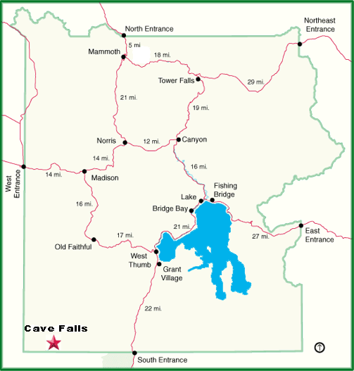
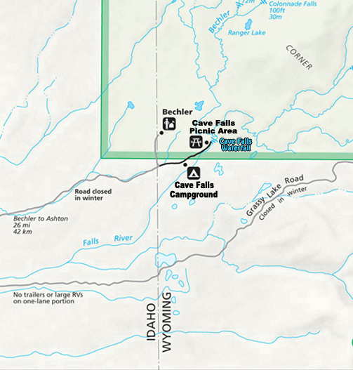
Take Highway 20 North from Idaho Falls or south from West Yellowstone, Montana to Ashton, Idaho. At Ashton take State Road 47 East for about six miles to the Yellowstone National Park / Cave Falls turn. This road is paved for about 5.5 miles and then turns to a dirt road. From where the pavement ends the road is noted as Cave Falls Road and it is a 10 mile drive to the Bechler Ranger Station on this dirt road. This road continues on to Cave Falls. Cave Falls is about 26 miles east of Ashton, Idaho.
On your return trip, you may also want to continue North on State Road 47 to Mesa Falls for a great view of Snake River Waterfalls. These falls are about 9 miles north of the Yellowstone National Park / Cave Falls turnoff.
Option Two - From Wyoming - to Bechler Area
You can drive in part way on the Ashton - Flagg Ranch Road (above Flagg Ranch on Highway 89 North) to Grassy Lake Reservoir. Grassy Lake is about 11 miles west of Flagg Ranch. This road starts out paved and then turns into a rough dirt road (high clearance vehicle recommended). You can park here and hike in if you would like. You can also drive, but this is a seasonal one lane dirt road and RVs and trailers are not allowed. With the right vehicle (high clearance four wheel drive), you can drive this route to the Bechler Ranger station and Cave Falls. You will need to get a detailed map from the ranger station as this route is not marked well on any other map.
~ Bechler Day Hikes ~
The Bechler Trail system offers a wide array of possibilities for the day hikes or rides. Be aware that hikers and stock users share the trials in Bechler. It is important for your own safety to be considerate of others. To avoid accidents, hikers may need to step off the trail momentarily and allow horses to pass. This information will answer many questions but if you have any further concerns or more involved curiosities, do not hesitate to ask a ranger at the Bechler Ranger Station. The station is open seven days a week in summer from 8:00 am to 4:30 pm.
~ Short Walks ~
Cave Falls to Bechler Falls - 3 miles round trip - negligible elevation change
From the Cave Falls Trailhead, walk north along the Falls River to the confluence of the Bechler and Falls Rivers. The trial continues along the river to Bechler Falls, another of the area's impressive cascades. Return via the same route.
This hike can serve as a opportunity to stretch one's legs after a picnic or an access for fishermen. Many rainbows and cutthroat trout can be caught in this stretch of the river. Before July, this trail is often closed to stock use due to wet conditions.
Cave Falls Loop - 7 miles - Little to no elevation change
Start from the Bechler Ranger Station and head east on the South Boundary Trail, which starts just south of the barn, and follow the signs to Cave Falls. You will walk through lodgepole pine forest; expect to ford a small stream about .5 mile from the station. The trail parallels the Cave Falls road for about a mile. From Cave Falls, head upstream on the Bechler River Trail past Bechler Falls and then another mile to the junction with the Bechler River Cutoff Trail, which goes southwest back to the ranger station. The trail is equally easy in the reverse loop. Look for moose, black bear and many riparian species.
Robinson Lake - 4 miles round trip - little to no elevation change
From the Bechler Ranger Station, take the Robinson Creek Trail, which forks to the left (west) immediately after the trailhead. This quiet trail travels primarily a through conifer forest for two miles before reaching Robinson Lake, which is covered with lily pads. This is a great spot to watch for moose, elk, and most of the riparian species found in the Bechler area. Return the same way.
Rocky Ford Loop - 7 to 8 miles round trip - little to no elevation change
From the Ranger Station, take the Bechler Meadows Trail north through lodgepole pine forest 3 miles to the Rocky Ford Cutoff Trail. From here, it would be worth your while to walk an extra half mile north and take a look at the beautifully expansive Bechler Meadows. Then retrace your trail back south to the Rocky Ford Cutoff Trail and head southeast to Rocky Ford. Instead of fording the river, head south on the Bechler River Trail to the Cave Falls Junction with the Bechler River Cutoff Trail, which goes southwest to the rangers station. Do not go toward Cave Falls but continue through the forest back to the ranger station. This trail, except for the .5 mile Rocky Ford Cutoff, remains relatively dry compared to the rest of the Bechler area. Look for beaver chewed trees and willows.
Terraced Falls - 3.6 miles round trip - elevation change 200 feet
Note: This trial is closer to Yellowstone's South Entrance than to the Bechler Ranger Station. It begins on Grassy Lake Road at Cascade Creek Trailhead. Follow the old dirt road about .25 mile, where the trail enters the park; take the left fork. Follow the signs north 1.4 miles along Cascade Creek and then the Falls River until the trail ends at Terrace Falls. Return the same way.
~ Longer Hikes ~
Union Falls - 14 miles - by Charles Maynard from "Waterfalls of Yellowstone © Copyright
Three routes present equal opportunities to reach the two falls. The referred route begins on the Reclamation Road below the Grassy Lake Dam (37 miles east of Ashton, Idaho and 11 miles west of Flagg Ranch). South Boundary Trail crosses the creek below the earthen dam on a roadway. Park on the southwest side.
The trailhead is actually just south of the park boundary. The trail follows the creek for 1.5 miles through a mostly lodgepole pine forest to a ford of the Falls River.
Care must be taken at this ford. The rocks are slippery and the current can be swift. In the early spring this can be a problem. Carry an old pair of shoes or sandals to wear for the ford. Just after the ford is a junction with the Pitchstone Plateau Trail which heads northeast (right) to go to the South Entrance Road.
Take Mountain Ash Trail which goes northwest (left) along what was once the old Marysville Road. Mormons used the road to move west from Jackson Hole in the 1880s. Some wagon ruts can still be seen in the stone of the trail. After crossing a ridge the trail descends through an open area over the same type of stone (welded ash tuff) that is found to the southeast at Terraced Falls.
Proposition Creek is crossed at 4 miles. The spur trail to Union Falls is reached at 5 miles. Soon, Mountain Ash Creek is crossed. A large campsite is above the trail junction between Mountain Ash Creek and the tributary with "Morning Falls." This is a good campsite but can be crowded. Making a base camp here allows for exploration and photography at various times of the day.
The remaining 2 mile trip up to Union Falls is fairly easy with the steepest part near the falls. A good overlook of the falls is at the end of the trail. Don't attempt to climb down the cliffs to the base of the falls.
A side trail to Meadows Falls is 1 mile after the campsite and before Union Falls. The trip to Morning Falls is on a maintained trail for only about .5 mile. The trail then is an unmaintained manway which follows the creek. It can be marshy and wet. Several scenic small cascades are along the route. A trip to Union Falls is complete in and of itself. However, it is a shame to miss the other falls in the area.
Another route which is actually more level and thus a little easier to walk begins at Fish Lake. The roundtrip distance to Union Falls with no side trips is 15.6 miles. It also has two fords which can be difficult. Another disadvantage is that the Fish Lake Road is poorly kept and hard to travel even in good weather.
Still another option is to walk from Cave Falls. The advantage is a good road to the trailhead. The disadvantage is that the roundtrip mileage is 23 miles. This puts it out of reach for a good day hike to take pictures. Also, there is a fording of the Bechler River at 3.2 miles. Once the river is crossed the trail is the same old roadbed mentioned above that Mountain Ash Trail follows. All three routes offer differing terrain and degrees of difficulty. It is best to choose what fits the experience and schedule of the hikers making the trip. Whatever route, Union and Morning Falls should not be missed.
Dunanda Falls - 16 miles - 600 feet elevation gain
Start at the Bechler Ranger Station and head north on the Bechler Meadows Trail. After 1.6 miles, take the Boundary Creek Trail northwest. You will need to ford Bartlett Slough, a body of stagnant water ranging from 2 to 4 feet deep, depending on the time of year. After crossing the slough, you will emerge into Bechler Meadows. Continue north; when you reach campsite 9A1, you will ford Boundary Creek. Soon the trail will lead through the Robinson fire burn. This burn was ignited by lighting and burned 8,000 acres of the Bechler forest in the fall of 1995. The brink of the Dunanda falls is one mile north of the burn at the end of the moderately steep climb with spectacular views of the Grand Tetons, meadows, and Silver Scarf Falls. Return to the ranger station via the same route.
This trip is somewhat arduous due to the long distance but is well worth the effort to get a glimpse of one of the park's most spectacular waterfalls.
Colonnade and Iris Falls - 18 - 20 miles - 400 feet elevation gain
From the Bechler Ranger Station take the Bechler Meadows Trail north 3.5 miles to the meadows. Cross Boundary Creek, continue on the trail through the meadows and ford the Bechler River at the upper end of the meadows. Look southeast for a view of the Grand Tetons and northwest to see Ouzel Falls in the adjacent drainage. From the Bechler Ford, the trail travels gradually up into the lush and diverse Bechler Canyon, home to some of the park's largest Douglas-firs. Watch for pikas in the talus slopes, as well as moose and bears. Soon you will reach Colonnade Falls, a two part waterfall with good fishing at its foot. The falls is the barrier for rainbow trout. Upstream one will find only cutthroat trout. After another mile, you will reach Iris Falls. Look for a rainbow glittering at the base of the falls. Return the same way.
Wildlife
Along the lakes, rivers and streams, you may see beaver, muskrat, river otter, osprey, bald eagle, moose, and waterfowl. In the meadows, look for sandhill cranes, moose, and coyotes, and an ever changing cast of wildflowers in spring and early summer.
About Bears:
The Bechler Region is home to many black bears and some grizzly bears. Although your chance of an encounter is low, your safety is not guaranteed. Minimize your risks by making loud noises, shouting, and singing. Hike in groups and use caution where vision is obstructed. Do Not hike after dark. Avoid carcasses; bears often defend this source of food. Never leave food unattended without hanging it at least 10 feet up in a tree and 4 feet out from the trunk. If you encounter a bear, give it plenty of room. Do not approach a bear; instead, back away slowly. Report all bear sightings to a ranger. Obtain detailed bear information at the Bechler Ranger Station.
~ Other Information ~
- Biting Insects -
Mosquitos, biting flies, and other pesky insects thrive here. Use a strong repellant.
- Horses and Other Stock -
Stock users have the right of way. Step off the trail to let them pass; be quiet.
- Hydrothermal Areas -
The thin ground in these areas breaks easily, and often overlies scalding water. Stay on the trail.
- Stream Crossings -
You will get your feet wet!
You may choose an extended trip or an alternate route from those mentioned. In so doing, be prepared to ford a river. The Bechler region is the wettest in Yellowstone and is dubbed, "Cascade Corner" for the many waterfalls descending from the Pitchstone Plateau. Spending time in the region, on cannot help but respect the power of water in the Bechler River drainage. Bring extra shoes for fords. Never cross barefoot. Carefully choose your route across rivers and pack gear in plastic bags in case your pack gets wet. Check at the ranger station for stream conditions.
- Wildlife -
You must stay at least 100 yards / 91 meters from bears and wolves, and at least 25 yards / 23 meters from all other animals - including birds, bison, elk, bighorn sheep, deer, moose, and coyotes. It is illegal to disturb animals from any distance.
- Additional Information -
Campsites have a three night limit, allow one party per site and wood fires (except when noted otherwise)
Food Poles exist at most campsites, however, they may not always be suitable for use.
A good topographic map is a must for camping and hiking in Yellowstone's backcountry.
This information was provided by a Yellowstone National Park Service Handout.
This information is provided by the National Park Service Backcountry Office. As with all information, it is subject to change, for current information, it is suggested that you call, write or visit the Backcountry Office when you arrive in the park. You can write or call the backcountry office at:
Backcountry Office
PO Box 168
Yellowstone National Park, WY 82190-0168
Phone: 307-344-2160
 |
 |
Bechler Hiking Information this is an Adobe pdf file
Yellowstone National Park
 |
 |
Bechler Hiking Information Page ~ Bechler Horseback Trails and Information Page
Yellowstone Map ~ Cave Falls Campground Page ~ Cave Falls Picnic Page ~ Cave Falls Waterfall Page ~ Bechler Ranger Station
Yellowstone National Park: Contact Page ~ Email Address ~ Phone Numbers

| Yellowstone National Park WebCams | |||||||
|---|---|---|---|---|---|---|---|
| Old Faithful Live | All Old Faithful | Old Faithful Static | Old Faithful VC | North Entrance | Mt Washburn | Mammoth | YVO WebCam |
| Entrance Cities and Gateway Towns | |||
|---|---|---|---|
| Gardiner, Montana | Silver Gate, Montana | West Yellowstone, Montana | Cooke City, Montana |
| Livingston, Montana | Cody, Wyoming | Jackson Hole, Wyoming | Yellowstone National Park |

| Links | |
|---|---|
| The Great Outdoors Net | Great Outdoor Recreational Places |
| Gardiner, Montana | World Humanity |