
Yellowstone National Park Hiking Guide
Yellowstone Hikes
| Yellowstone Hikes | ||||
|---|---|---|---|---|
| Beaver Ponds | Beula Lake | Clear Lake | Fairy Falls | Heart Lake |
| Ice Lake | Lone Star | Mt Washburn | Observation Peak | Pebble Creek |
| Seven Mile Hole | Trout Lake | |||
Beula Lake Trail by Bob Bielski
Beula Lake Trail by Bob Bielski |
|
|---|---|
| The Beula Lake Trail starts in the very southern part of the park between the South Entrance and the Bechler Area. One needs to leave the park and take the Grassy Lake Road. It is about 9 miles or so to the trailhead. Once on the trail, the first 3/8 or 1/2 mile are uphill until you reach the boundary and re-enter the park. The rest of the trail is fairly level and enjoyable. For the most part you are walking thru wooded forest but not really dense. The day I went it was very overcast with a low ceiling so can't comment much on the far away views. The lake itself is a little less than 3 miles from the trailhead. I hear it is a popular place to fish for cutthroats. There was also was a note on the trailhead sign that a Grizzly sow and 2 cubs were spotted on the far side of the lake when I went. That's just what I needed to read!! I would recommend this hike to anyone of all abilities. A good short hike with no crowds off the beaten path. | |
| Click Here to see a: GoogleEarth Beula Lake Satellite Image | |
~ Back to Index ~
Trout Lake Trail by Steve Stuller
Trout Lake Trail by Steve Stuller |
|
|---|---|
| Trout Lake is a beautiful mountain lake in the Northeast portion of the park. It is a good place to see otters, moose, and all kinds of other wildlife. It is in grizzly country so be bear aware. The trail head is between Pebble Creek Campground and the Soda Butte Cone on the Northeast Entrance road. The trail itself is very short, .5 mile or less, but it is a steep uphill climb the entire way. Pace yourself. The picturesque lake is framed by trees on three sides and the shoulders of Druid Peak on the West side. Look for trout from the footbridge that crosses the outlet stream of Trout Lake. Nearby is Buck Lake if you want to visit another mountain lake. There is no designated trail to Buck Lake, but it is easy to find. Circle around Trout Lake on the northern bank and before you cross the inlet stream, head due north. Buck Lake is just over that hill 200 yards. | |
| Click Here to see a: GoogleEarth Trout Lake Satellite Image or a GoogleEarth Trout Lake Topo Map | |
~ Back to Index ~
Lone Star Geyser Trail by Kristine Branstetter
Lone Star Geyser Trail by Kristine Branstetter |
|
|---|---|
| The Trailhead is about 2 miles south of the overpass at Old Faithful just beyond the parking lot for Kepler Cascade.
The trail is a portion of the old road that used to take travellers between Old Faithful and West Thumb Geyser Basin so it is partially paved and bicycle accessible. It is 2.5 miles to Lone Star Geyser, which erupts about every 3 hours. There is a log book at the geyser where visitors write down when they see the geyser erupt. This is an easy, flat hike that is great for families. The Lone Star Trail is also the jumping off point for the Bechler Trail and Shoshone Geyser Basin. This is also a popular cross-country ski trail in the winter. To access the trail in the winter, you will have to take a ski drop from the Old Faithful Snowlodge to the trailhead and then ski back to the Old Faithful Snowlodge (there are no pick-ups). |
|
| Click Here to see a: GoogleEarth Lone Star Trail Satellite Image | |
~ Back to Index ~
Clear Lake Trail by Steve Stuller
Clear Lake Trail by Steve Stuller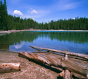 |
|
|---|---|
| On the south side of the Grand Canyon of the Yellowstone is a network of shorter trails linking Clear Lake, Lilly Pad Lake and Ribbon Lake. Clear Lake is actually in a geothermal area with mud pots and fumaroles dotting the nearby landscape. The shortest route to Clear Lake is from the Upper Falls parking lot on the south side of the canyon. It is about 8/10ths of a mile to the lake, or you can take the trail from the parking lot at Chittendon Bridge which is about ¼ mile longer. The trail from the Upper Falls parking lot starts out with a gentle climb across the sagebrush meadow and eventually enters a more forested area with grassy meadows. The trail winds its way through the thermal area for another ½ mile and comes to a junction. One mile to the right is Ribbon Lake. Just a short hike to the left you’ll find Lilly Pad Lake. That trail continues on to become the Canyon rim trail with breathtaking views of the Grand Canyon of the Yellowstone. At the Canyon rim, Point Sublime is ¾ mile to the right. The parking lot at Artist Point is ¾ mile to the left. | |
| Clear Lake/Lilypad Lake/Artist Point Loop by Rick Ramsey | |
| This hike in the vicinity of the Grand Canyon of the Yellowstone gives as much variety in a relatively short distance as any in the park. You can start at either the Uncle Tom’s trailhead parking area (walk east across the Artist Point road to start the hike) or the Chittenden Bridge parking area (first parking to the right after you turn off the main loop road onto the Artist Point road). I prefer the second option, even though it adds a few tenths of a mile to the overall hike—I like the meadows you walk through to begin. Either way, your first destination is Clear Lake, a nice little lake in the woods with some bubbling action along the shore from thermal activity (nothing dramatic, but interesting to see). From there you shortly reach a small but neat thermal area with some fumaroles, mud pots and such—be careful going through here. Following the thermal area, you come to Lilypad Lake—this is where you should take a left turn to get to the canyon rim (continuing on will eventually take you to Ribbon Lake, which is nice enough but to me wasn’t different enough from the other lakes to justify going several more miles). Reaching the canyon, turn to the left, and again be careful along the rim. This stretch doesn’t gain much elevation, but you’ll do some wandering up and down along the ridges of the canyon—nothing strenuous, but be aware that it isn’t “flat.” Civilization returns at Artist Point, where the most famous view of the canyon (and lots and lots of people) can be found. Continuing on the rim trail will eventually take you back to the Uncle Tom’s trailhead, where you either started or can cross the road to get back to the Chittenden Bridge area. Total distance is in the 3-4 mile range, depending on how exactly you do the hike. Overall, a great introduction to Yellowstone away from the road and the crowds. | |
| Click Here to see a: GoogleEarth Clear Lake Satellite Image | |
~ Back to Index ~
Fairy Falls Trail by John & Carlene Uhler
Fairy Falls Trail by John & Carlene Uhler |
|
|---|---|
| Roundtrip - 5 to 7 miles (8 - 11.3 km) depending on route. Difficulty - Easy. Fairy Falls, 200 feet (61 m) high, is one of Yellowstone's most spectacular waterfalls. Fairy Falls may be reached by two routes: 1. The Steel Bridge trailhead is located 1 mile (1.6 km) south of Midway Geyser Basin and 4.7 miles (7.6 km) north of Old Faithful. Follow the road approximately 1 mile (1.6 km). The trail then turns west (left) for 1.6 miles (2.6 km) through burned lodgepole pine forest to the falls. 2. Drive south on Fountain Flat Drive until you reach the barricade. Walk south along the road for approximately 1.0 mile (1.6 km). The trail then turns west (right) and continues 1.6 miles (2.6 km) to the falls. This is a nice hike and trail. You can see fire damage from the 1988 fires that give a great view of the new undergrowth and regeneration of the forest and plant life. On the hike from the Steel Bridge, you hike along the edge of Grand Prismatic pool, it is a beautiful area. Thermal features along the way, Imperial Geyser, Spray Geyser. |
|
| Fairy Falls by Rick Ramsey | |
| There are a couple of different options to do this hike, which can be anywhere from around 4 to 5 miles round-trip depending on which you choose. The exact option we used back in 1993 no longer exists, as it utilized a parking area at the end of a dead-end road that is no longer open to vehicles. Whichever option you choose, try to go with one that passes through the meadows near the Midway Geyser Basin, as this is the most interesting section of the trail—much of the rest of the hike goes through a flat and fairly monotonous section of woods. For this reason it is not one of my “top-flight” hikes, although the falls themselves are very pretty and impressive. I am somewhat in a minority here, though, as I have heard many folks say it is among their favorites. If you choose it and love it, I’ll claim credit for pointing you there, but if you don’t I’ll say I told you so, ha. Personally, if I only had time for one waterfall hike in this general area (not too far from the Old Faithful complex) I would choose Mystic Falls (at Biscuit Basin). | |
| Click Here to see a: GoogleEarth Fairy Falls Satellite Image | |

~ Back to Index ~
Mount Washburn Trail by Rick Ramsey
Mount Washburn Trail by Rick Ramsey |
|
|---|---|
| This is considered by many to be the single biggest “must-do” hike in Yellowstone. While I wouldn’t necessarily agree with that, the view from the top is impressive, as you can see for literally dozens of miles in all directions. The Grand Canyon of the Yellowstone is laid out to your east, Hayden Valley (and even the Grand Tetons on a haze-free day) are visible to the south, and mountains ring you to the west and north. Plus, this is the one spot where you have a pretty good chance of seeing bighorn sheep. Just be aware that it is a long slog uphill—there are two choices of trailheads, one each on the south and north sides of Dunraven Pass between Canyon and Tower, and both climb well over 1000 feet in 2 and a half to 3 miles. It’s also much cooler at the top, so take that into consideration. There is a lookout station on top that will provide some shelter if the elements take a turn for the worse. | |
| Click Here to see a: GoogleEarth Mount Washburn Satellite Image | |

~ Back to Index ~
Seven Mile Hole Trail by Rick Ramsey
Seven Mile Hole Trail by Rick Ramsey |
|
|---|---|
| Distance: 11 miles (17.7 km). Estmated time: 6 to 8 hours. Difficulty: Strenuous. Not for individuals with either heart or respiratory problems. Trailhead: Glacier Boulder pullout on the road to Inspiration Point. I can never decide whether I should “officially” recommend this hike or not. On the one hand, the spot it reaches is really cool, and is about the only reasonable way to reach the Yellowstone River within the Grand Canyon. On the other, it is a fairly long hike that mostly passes through non-descript woods, and the final section (drops 1,000 feet the last 1.5 mile) is an almost scary descent to the river (and the accompanying tromp back UP the hill is a gasser). Still, being on the edge of the rushing river is an undeniable thrill, so figure it out for yourself—just consider yourself warned. If you go, go to the Canyon area and head out on the one-way North Rim drive, taking the side road toward Inspiration Point. Shortly before you reach the point, park at the Glacier Boulder trailhead. The first four miles or so of the trail are through the afore-mentioned woods, with only an occasional glimpse of the canyon. The final mile (the trail is 5 miles each way—the “Seven Mile” part refers to the distance downstream from the Lower Falls) drops 800 feet or so down an uneven path, past a couple of small thermal areas, to the river. Expect to see some hardy fishermen who will look at you funny when they realize you have no fishing equipment. |
|

~ Back to Index ~
Beaver Ponds Trail by Rick Ramsey
Beaver Ponds Trail by Rick Ramsey |
|
|---|---|
| Distance: 5 miles (8 km). Estmated time: 2 to 3 hours. Difficulty: Moderately Strenuous. Trailhead: Between Liberty Cap and the Stone House next to the Mammoth Terraces. This is about a 5-mile loop starting from Mammoth Hot Springs, next to the Liberty Cap formation. It starts off beside a terrace and then climbs for a mile or so (somewhat more steeply than a couple of guidebooks tend to state) through the trees. Leveling out, you then pass alternately through meadows and stands of aspens and other trees before reaching the first of the ponds. At certain times of year this area is known for the chance to spot a variety of wildlife, but when we did the hike in early August there was (predictably) not much to be seen. You return after passing all of the ponds (4 or 5 all together) on a ridge high above the road that connects the Mammoth complex with the border town of Gardiner. Sections of this trail could be hot and exposed on a warm midday, so consider doing it as an early or late-day hike. Some outstanding panoramic views. |
|
| Click Here to see: GoogleEarth Satellite Image and Topo Maps | |

~ Back to Index ~
Pebble Creek Trail by Rick Ramsey
Pebble Creek Trail by Rick Ramsey |
|
|---|---|
| Distance: 12 miles (19.3 km). Difficulty: Strenuous. Trailhead: Warm Creek Trailhead just inside the NE Entrance or Pebble Creek Campgrounds. This is maybe the single most impressive hike I’ve taken in Yellowstone, at least from a scenery perspective—but it is also the longest and hardest, so don’t believe anyone who tells you it’s an “easy” hike. You start at the Warm Creek trailhead, just inside the Northeast Entrance station, and immediately start up through the trees. Up, up, up and up you go—this is a steep hill, and you’re going up it for a full mile and a half until you reach the top of a ridge and drop down into a valley on the other side. Once to that point, though, the hard work is essentially over. You now walk on a very gently descending trail, mostly through open meadows with spectacular views of the mountains in each direction, for the next few miles. You have to cross the creek several times, but the first two at least are not difficult. That’s as far as I went, the second crossing, which is about 4 miles from the trailhead. From this point on the trail continues on all the way to Pebble Creek Campground, a total of about 12 miles, but to do this you would have to arrange for a shuttle or pick up at the other end. A beautiful walk, and maybe my favorite of my Yellowstone hikes, but man, is that first hill a beast. |
|
| Click Here to see: GoogleEarth Satellite Image of Pebble Creek Hike | |
~ Back to Index ~
Observation Peak Hike
Observation Peak Hike |
|
|---|---|
| Distance: 11 miles (17.7 km). Difficulty: Strenuous (1,400 foot (425 meters) in 3 miles (4.8 km). Trailhead: Cascade Lake Trailhead, 1.25 miles (2 km) north of the Canyon Junction on the Tower - Canyon road. Hike to a high mountain peak for an outstanding view of the Yellowstone wilderness. Trail passes through open meadows to Cascade Lake. Beyond the lake, the trail climbs 1,400 feet in 3 miles through a whitebark pine forest. Past Cascade Lake no water is available. Not recommended for individuals with heart or respiratory health problems. |
|
| Click Here to see: GoogleEarth Satellite Image and Topo Map of Observation Peak Hike | |

~ Back to Index ~
Ice Lake to Wolf Lake to Grebe Lake Hike
Ice Lake to Wolf Lake to Grebe Lake Hike |
|
|---|---|
| Distance: 9 +/- miles / 14.5 +/- km, depending on your interests & detours. Difficulty: Easy; relatively flat, 4 water crossings. Trailhead: Ice Lake trailhead parking area on Norris to Canyon road. End: Grebe Lake trailhead parking area on Norris to Canyon road. Misc: As this is a one way hike, you will need to plan for transportation back to your car. Do not leave valuables in your car. This hike can be reversed. Very good fishing for grayling and trout in Wolf and Grebe Lakes, best around any in-flows/outflows of the lakes. The hike is also a nice overnighter with two campsites on Wolf Lake and four campsites on Grebe Lake. Check the Yellowstone Backcountry Planner for more info. Water is a necessity. Bear spray, rain gear and insect repellant is strongly recommended. Camera, binoculars, fishing gear and permit are nice to have. The trailhead has limited parking, but is not often crowded. Sign in at the trail register. The trail from the register to Ice Lake is fairly level, through areas from the 1988 fires. You will soon come to an intersection, follow the trail left, the right spur dead-ends near Ice Lake. The trail follows the shoreline along Ice Lake to another intersection; take the trail right continuing along Ice Lake. Elk are sometimes seen here, we saw and reported a Mountain Goat on one occasion; this area apparently has them occasionally according to the Rangers. As you leave Ice Lake there is another trail that branches right, continue straight to your first crossing of the Gibbon River. About a half mile after crossing the Gibbon for the first time, a trail will enter from the right, continue straight thru some seasonally wet areas and rolling terrain, thru some 1988 fire areas till your next crossing of the Gibbon in about 2 miles. There may be some downed trees to use as bridges, or you can wade across. You will have an uphill stretch over a ridge, then down hill until you reach Wolf Lake in about ½ mile. At this point you have done about 4 miles. This is a nice spot for a fishing break or lunch; just pick a spot overlooking the lake to reduce any uninvited insect guests. After your break, the trail continues past Wolf Lake and crosses the Gibbon for the last time. You will need to wade this crossing. The trail continues past the 2 campsites, thru some wooded and meadow areas reaching the Grebe Lake outflow in about 1 ¼ miles. This is an excellent spot to try for Grayling. The trail continues along the shoreline of Grebe Lake; look for Osprey, White Pelicans and Mergansers fishing in the lake. This is also a very nice spot to take a break, have lunch or, if time permits, just lay in the grass. Grebe Lake also holds a good population of Rainbow Trout, but fishing from shore can be difficult. The trail intersects with the trail to Cascade Lake that heads off to the left. Keep right thru grassland, Moose are sometimes seen here, and continue across a narrow water crossing toward the spur to the last campsite at Grebe Lake, bear left and uphill. The trail is single track and the last leg of about 3 miles of easy walking. The trail soon widens thru trees and some 1988 burned areas, past meadows with occasional Elk. The trail becomes a fire road for the last stretch to the trail register. Sign out and make your way back to your car. |
|
| Click Here to see: GoogleEarth Satellite and Topo Images of Ice Lake to Grebe Lake Hike | |

~ Back to Index ~

Otter at Trout Lake by John William Uhler © Copyright All Rights Reserved


| Yellowstone National Park WebCams | |||
|---|---|---|---|
| Old Faithful Live | All Old Faithful | Old Faithful Static | Old Faithful VC |
| North Entrance | Mt Washburn | Mammoth | YVO WebCam |
| Entrance Cities and Gateway Towns | |||
|---|---|---|---|
| Gardiner, Montana | Silver Gate, Montana | West Yellowstone, Montana | Cooke City, Montana |
| Livingston, Montana | Cody, Wyoming | Jackson Hole, Wyoming | Yellowstone National Park |

| Links | |
|---|---|
| The Great Outdoors Net | Great Outdoor Recreational Places |
| Gardiner, Montana | West Yellowstone, Montana |
 |  |