
Yellowstone National Park Road Information
Index
| Yellowstone Road Information | ||||
|---|---|---|---|---|
| Opening | Closing | Construction | Information | Getting Here |
The only road open in Yellowstone National Park is Highway 89 at Gardiner, Montana through the North Entrance. This road will take you to park Headquarters at Mammoth Hot Springs and from Mammoth Hot Springs to Silver Gate and Cooke City, Montana. No other entrance to Yellowstone is open at this time. The East, Northeast, South, and West entrances will open in spring (April and May 2024) to regular vehicle entrance and travel.
~ Click on an Area of the Map for more Information ~
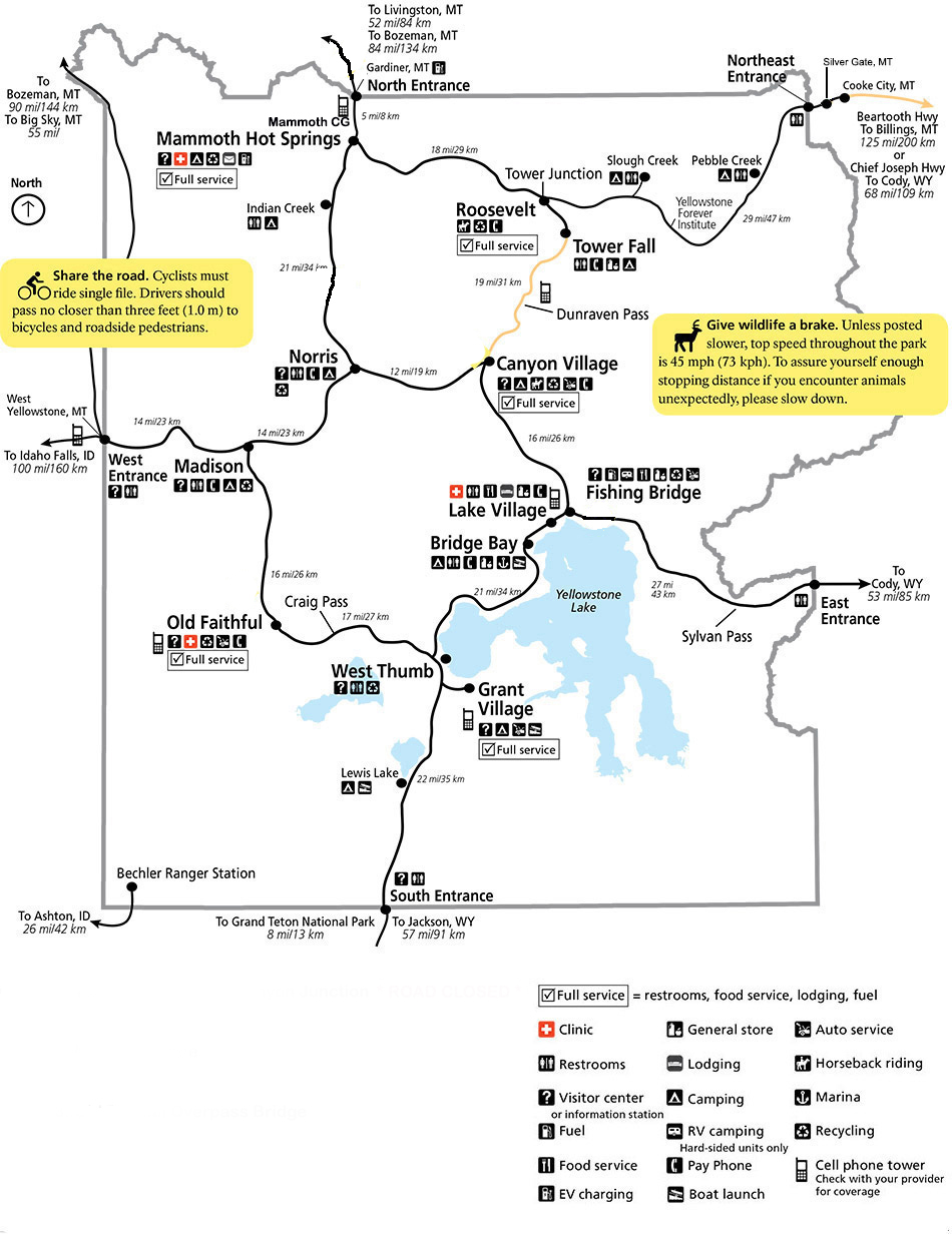
Yellowstone National Park Roads Updated in March 2024
For an Adobe pdf copy of the above map, Click Here
Roads Open
Yellowstone National Park 2024 Opening Schedule
Yellowstone National Park is our first and grandest national park. Only a part of Yellowstone is open all year. The North Entrance at Gardiner, Montana is Open Year Round. The road from Gardiner to Mammoth Hot Springs and from Mammoth to Silver Gate and Cooke City, Montana is maintained for winter vehicle travel. In winter, vehicles are usually required to have snow tires and may be required to have chains to enter the park. The road though plowed and maintained, will be snow or ice packed in areas. The North Entrance is open 24 hours, 7 days a week, 365 days a year, but there may be temporary closures due to weather or other conditions. Also of note, you cannot travel east of Cooke City, Montana until late spring when the road east of Cooke City is plowed open for vehicle travel. Please Note: This schedule is subject to change due to weather, fire, or other conditions.
| Yellowstone National Park Entrance Opening Schedule | |||
|---|---|---|---|
| North Entrance | Open | Year | Round |
| West Entrance | Friday | 19 April | at 8:00 AM |
| East Entrance | Friday | 03 May | at 8:00 AM |
| South Entrance | Friday | 10 May | at 8:00 AM |
| Old Faithful to West Thumb | Friday | 10 May | at 8:00 AM |
| Canyon to Tower | Friday | 24 May | at 8:00 AM |
| Beartooth Highway | Friday | TBD | at 8:00 AM |
Roads Close
Yellowstone National Park 2024 Closing Schedule
This is the latest 2019 Entrance and Road Closing Schedule from the park service. Please Note: This schedule is subject to change due to weather, fire, or other conditions.
| Yellowstone Entrance and Road Closure Schedule | |||
|---|---|---|---|
| North Entrance | Open | Year | Round |
| Tower Junction to Tower Falls | |||
| Beartooth Pass (depends on weather) | TBD | at 8:00 AM | |
| East, South, and West Entrances | Monday | 04 Nov | at 8:00 AM |
Road Construction
Yellowstone National Park Road Construction Map

~ Road Construction ~
2024 Construction Projects Affecting Roads
2024 Projects
1. Lewis River Bridge ~
Lewis River Bridge 2024 Schedule

2. Yellowstone River Bridge ~
Yellowstone River Bridge 2024 Schedule


For an Adobe pdf copy of the above map, Click Here
Road Information
Yellowstone National Park 2024 Road Information

Click on a Name or Area for more Info or a Map
Yellowstone National Park is a large park at 2.2+ million acres and 251 miles of roads. At this point in time (2024), the roads are the best they have been for a very long time. There has been a lot of new construction and the park service has tried to do overlays on the other areas that were in bad need of repair.
All of Yellowstone roads are two lanes. There is limited space for pulling off the roads, and limited passing zones. There are a few roads with shoulders for bike riders. There are roadside pullouts for viewing areas, or wildlife, or for parking for hikes. Slower traffic is strongly encouraged to be courteous and think of other drivers and visitors and to utilize pullouts.
There are several areas where there are steep grades and winding narrow roads. These areas are: Sylvan Pass (8,530 feet / 2,600 meters), Craig Pass / Continental Divide (8,391 feet / 2558 meters), Mammoth Hot Springs to Gardiner, Montana (6,239 feet / 1,902 meters). The road from Mammoth Hot Springs to Gardiner is narrow with some fairly sharp turns, it is best to use low gears as your brakes will heat up. Some visitors who arrived in Gardiner wanted to find a garage to look at their brakes as they were hardly working by the time they got to Gardiner. All that was needed was time to allow their brakes to cool as they had overheated from usage on the drive down.
If you look at the above park map, you will note that the park roads are roughly in a figure eight, with an Upper Loop, a Lower Loop, and a Grand Loop. The total road mileage in the park is 251 miles, the Upper Loop is 70 miles around, the Lower Loop is 96 miles around, and the Grand Loop is 142 miles around. The park top speed limit is 45 miles per hour, with many areas with lower speeds. The speed limit is strictly enforced, you will not want to get a ticket while on vacation and most animal deaths in the park involve vehicle accidents. Be careful and enjoy your time in Yellowstone.
During the main tourist season (mid Jun - mid Sep) the roads are crowded. There will be times that wildlife will be on the road, they have the right of way. There will also be what is known as buffalo jams, elk jams, bear jams and wolf jams. You cannot stop and park your vehicle in the middle of the road to take pictures or watch. You have to pull completely off the roadway so you are not blocking traffic. Utilize pullouts, parking areas, and/or road shoulders if available.
It is hoped that this information will be helpful in planning your trip and time in Yellowstone. Be careful, have fun and enjoy the beauty, magic, and wonders of Yellowstone!
| Yellowstone National Park Milage | ||||||
|---|---|---|---|---|---|---|
| Canyon | Grant | Lake | Mammoth | Old Faithful | Roosevelt | |
| Canyon | -- | 40 | 17 | 33 | 42 | 19 |
| Grant | 40 | -- | 24 | 73 | 19 | 59 |
| Lake | 17 | 24 | -- | 49 | 38 | 36 |
| Mammoth | 33 | 73 | 49 | -- | 51 | 18 |
| Old Faithful | 42 | 19 | 38 | 51 | -- | 61 |
| Roosevelt | 19 | 59 | 36 | 18 | 61 | -- |
Milage Chart from Gardiner, Montana
Yellowstone National Park's North Entrance
| North Entrance at Gardiner, Montana | Less than a mile |
| Mammoth Hot Springs | 5 miles |
| Tower | 23 miles |
| Norris Geyser Basin | 26 miles |
| Canyon | 38 miles |
| Madison | 40 miles |
| Northeast Entrance | 52 miles |
| Silver Gate, Montana | 53 miles |
| West Entrance | 54 miles |
| West Yellowstone, Montana | 54 miles |
| Yellowstone Lake | 54 miles |
| Old Faithful | 56 miles |
| Cooke City, Montana | 56 miles |
| West Thumb | 73 miles |
| East Entrance | 81 miles |
| South Entrance | 95 miles |
| Cody, Wyoming | 134 miles |
| Jackson Hole, Wyoming | 160 miles |


| Yellowstone National Park WebCams | |||
|---|---|---|---|
| Old Faithful Live | All Old Faithful | Old Faithful Static | Old Faithful VC |
| North Entrance | Mt Washburn | Mammoth | YVO WebCam |
| Entrance Cities and Gateway Towns | |||
|---|---|---|---|
| Gardiner, Montana | Silver Gate, Montana | West Yellowstone, Montana | Cooke City, Montana |
| Livingston, Montana | Cody, Wyoming | Jackson Hole, Wyoming | Yellowstone National Park |

| Links | |
|---|---|
| The Great Outdoors Net | Great Outdoor Recreational Places |
| Gardiner, Montana | West Yellowstone, Montana |
 |  |