

| Mesa Falls ~ Upper Falls | |
|---|---|
| Location | 44° 11' 16.04" N / 111° 19' 48.19" W |
| Elevation | 5,601 feet / 1,667 meters |
| Fall Type | Plunge |
| Height | 114 feet / 35 meters |
| Width | 300 feet / 91 meters at the crest of the falls |
| River | Henry's Fork of the Snake River |
| Access | Idaho Highway 47 - Mesa Falls Scenic Byway |
|
Upper Mesa Falls - Why a Waterfall Here? Upper Mesa Falls was formed when Henry's Fork cut its canyon deep enough to encounter an especially resistant layer of hard volcanic rock. As the canyon deepened downstream, a ledge formed overwhich the river flowed. Because the layers beneath the resistant one are softer, the falling water undercut the ledge above, eventually causing pieces of the harder rock to break away. This creates the sharp lip and spectacular drop of the waterfall you see today. Upper Mesa Falls is approximately 114 feet / 35 meters high and 300 feet / 91 meters wide. The average volume of water flowing over the falls varies between 600 to 1,500 cubic feet per second. This equates to 387 million to 967 million gallons of water per day. Each sunny day, a small rainbow is created by sunlight passing through the mist accents the falls from approximately 9:00 a.m. to 1:00 p.m. Mesa Falls Recreation area has lots of things to do. You can simply enjoy the power and beauty of the falls and watch the osprey and eagles that frequent the area. The walkways make viewing safe for all. Please--to ensure your own and your family's safety--stay on the walkways at all times. |

| Mesa Falls ~ Lower Falls | |
|---|---|
| Location | 44° 10' 32.17" N / 111° 19' 15.07" W |
| Elevation | 5,470 feet / 1,707 meters |
| Fall Type | Plunge |
| Height | 65 feet / 20 meters |
| Width | 70 - 80 feet / 21 - 24 meters at the crest of the falls |
| River | Henry's Fork of the Snake River |
| Access | Idaho Highway 47 - Mesa Falls Scenic Byway |
|
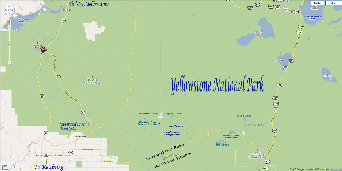
The Tale of Two Falls Both Upper Mesa Falls and Lower Mesa Falls were created under simular conditions, but the nature of the volcanic rock at each location has created different forms for each waterfall. Lower Mesa Falls has a horseshoe crest, whereas Upper Mesa Falls has a straight crest. (Forest Service Information) Mesa Falls was placed into Public Ownership on December 12, 1986. Targhee National Forest aquired the land through a Land Exchange with Montana Light and Power. The Targhee National Forest and Idaho Department of Parks And Recreation have entered into a partnership to improve safety and recreational opportunities of the site. They share equally in the Development and Operation of the area(US Forest Service and Idaho Department of Parks and Recreation). Lower and Upper Mesa Falls have been enjoyed by travelers since the early 1900's. Location: Mesa Falls are located about 15 miles west of Yellowstone National Park in Eastern Idaho. Getting Here: There are two main access routes to Mesa Falls: From the North: 1. From West Yellowstone, Montana take US Highway 20 West towards Rexburg, Idaho. It is about 51 miles from West Yellowstone to the Upper Falls. 2. Just north of Harriman State Park turn left onto Idaho State Road 47, this is known as the Mesa Falls Scenic Byway. 3. You will first come to Upper Mesa Falls on your right or west side of the road (about 12 miles from the turnoff from Highway 20). 4. Lower Falls is less than a mile south from the Upper Falls. 5. This scenic byway is about 28 miles from the north exit off Highway 20 near Harriman State Park to Ashton, Idaho on Highway 20. From the South: 1. From US Highway 20 head north to Ashton, Idaho. 2. In Ashton, turn right or east onto Idaho State Road 47 this is known as the Mesa Falls Scenic Byway. 3. Follow this route for approximately 16 miles to the turnoff on the left or west to Lower Mesa Falls and campground 4. Upper Falls is less than a mile north of the Lower Falls, also on the left or west side of the road. It is approximately 27 miles to the Bechler Ranger Station and Cave Falls Waterfall or Cavefalls Picnic Areas or Cavefalls Campground. The ranger station, waterfall and picnic areas are in Yellowstone National Park, the campground is locate just outside the park. Mesa Falls Scenic Byway - information provided by the Idaho Department of Parks and Recreation and the US Forest Service The Mesa Falls Scenic Byway, designated in 1989, was the original route to Yellowstone National Park prior to construction of U.S. Highway 20. The southern end begins in the town of Ashton, Idaho, a pleasant rural community, located near the Henry's Fork of the Snake River on U.S. Highway 20. A paved, two lane road winds its way through scenic farm lands of potatoes, barley, and alfalfa before entering the Three Rivers Canyon area and climbing to a mixed forest of lodgepole pine, Douglas fir, and aspen. The Byway makes a loop, rejoining Highway 20 approximately 28 miles to the north at Harriman State Park. Along the Byway, you can see the succession of wildflowers throughout the seasons. Moose, bear, deer, elk, marmots, coyotes, martens, and many other small mammals and birds are also seen. Clearcuts that are changing back into forest and grazing cattle illustrate the multiple uses of the Caribou-Targhee National Forest. The Mesa Falls Scenic Byway is not plowed in the winter. It is a groomed snowmobile trail with parking at Bear Gulch and Highway 20 near Harriman State Park. Mesa Falls is a popular destination for both snowmobilers and cross country skiers. |

Big Falls Inn
|
Holding a unique niche in Idaho's history, Big Falls Inn was built around 1915 by the Snake River Electric Light and Power Company. Although it may have originally been constructed at a combination office and residence for workers, it eventually evolved into a well known waystation on the Yellowstone highway. With its spectacular setting the Inn also became a popular spot for dances and social gatherings for local ranchers, farmers, sportmen and tourists. In 1936, Big Falls Inn was sold to Montana Power Company who utilized it as a company resort. It was also used as a restaruant and dance hall, Boy Scout lodge, and as a retreat/meeting hall. In 1986, the Forest Service aquired the Inn from Montana Power through a land exchange. The Big Falls Inn opened as an interpretive center in the year 2001 . Visit the Center to see exhibits on the geology of the falls and canyon, history of the lodge, the river ecosystem, plants and animals of the area, the Forest ecosystem, cultural history of the area from prehistoric times to present, and maps of other parks and points of interest in the area. There are several hiking trails in the area. The one-mile trail to the Lower Falls being approximately 200 yards to the east of Big Falls Inn. There is an improved hiking trail from Grand View Overlook to Bear Gulch. From Bear Gulch south to Warm River Campground, the old railroad bed is a non-motorized trail. North from Bear Gulch, the trail is open to motorized vehicles less than 50 inches wide. This trail may be taken all the way to the Montana boarder (32 miles). Information provided by the Idaho Department of Parks and Recreation and the US Forest Service |


Wildlive Videos
Yellowstone Wildlife Videos
Geysers and Thermals
Yellowstone Geysers and Thermal Videos
| Yellowstone Geyser and Thermal Videos | |
|---|---|
| Beehive Geyser Eruption | Old Faithful with Bison |
| Beehive Geyser Eruption Two | Pocket Basin |
| Fan and Mortar | Roaring Mountain |
| Grand Geyser | Rocket and Grotto |
| Old Faithful One | West Thumb |
Waterfalls
Yellowstone Waterfall Videos
| Yellowstone Waterfall Videos | ||
|---|---|---|
| Cave Falls | Mesa Falls | Undine Falls |
| Gibbon Falls | Rustic Falls | Upper Falls |
| Lower Falls | Tower Fall | Wraith Falls |


| Yellowstone National Park WebCams | |||
|---|---|---|---|
| Old Faithful Live | All Old Faithful | Old Faithful Static | Old Faithful VC |
| North Entrance | Mt Washburn | Mammoth | YVO WebCam |
| Entrance Cities and Gateway Towns | |||
|---|---|---|---|
| Gardiner, Montana | Silver Gate, Montana | West Yellowstone, Montana | Cooke City, Montana |
| Livingston, Montana | Cody, Wyoming | Jackson Hole, Wyoming | Yellowstone National Park |

| Links | |
|---|---|
| The Great Outdoors Net | Great Outdoor Recreational Places |
| Gardiner, Montana | West Yellowstone, Montana |
 |  |